Friday, June 30, 2006

Paanyaya Sa Lahat

I got a forwarded letter from my orgmate, John Clemente, who also is the chairperson for the Tabang sa Kabikolan. In behalf of the committee that has been organized to help out victims of the Mt. Bulusan eruption, he's inviting everyone to join one of their meetings this July 14th.

Read on for more information.

Ang TABANG SA KABIKOLAN ay isang malawak na kalipunan ng mga organisasyon, indibidwal, estudyante, at propesyunal sa Metro Manila. Ito ay binuo noong Hunyo 14, 2006. Pangunahin naming layunin ang makatulong sa mga biktima ng pagputok ng Bulkang Bulusan.

Inaaanyayahan namin kayong dumalo sa unang GENERAL ASSEMBLY ng TABANG SA KABIKOLAN para sa pagpapakilanlan at pagpaplano ng mga hakbangin para sa pagkakalap ng mga relief goods at iba pa na makakatulong sa mga komunidad na apektado ng pagputok ng Bulkang Bulusan.

Ito ay magaganap sa ika-6 ng Hulyo 2006 (Hwebes) sa tambayan ng UP Ibalon sa Lorena Barros Hall, Vinzons Hill, UP Diliman, Quezon City.

Makipag-ugnayan na lamang kay John Clemente sa 09195775736 o mag-email dito.

Inaasahan namin ang inyong pagdalo at pag-imbita pa sa iba pang organisasyon at indibidwal na nasa Metro Manila.

Mabalos saindong gabos!

Sumasainyo,

John Clemente

Soli Letter Ng Tabang Sa Kabikolan

Here's a screenshot of the actual letter.


Post ko na lang dito ang laman mismo ng letter. So if you are interested, you can contact me or anybody else listed dun. May contact information naman. Thanks!


30 June 2006

_________________________
_________________________
_________________________
_________________________


Dear ___________,

Good Day!

Tabang sa Kabikolan is a quick response network of Bicolanos and organizations in Metro Manila. The network was initiated and spearheaded by the UP Ibalon, a regional organization of Bicolanos in UP Diliman.

Tabang sa Kabikolan's activities consist mainly of collecting relief and helping with the actual relief operations for the communities affected by the eruption of Mt. Bulusan. At present, we are in the process of building the network - inviting organizations, schools, institutions and individuals, while soliciting relief goods which we can immediate give to the affected communities through relief organizations in the region. We have already linked up with the People's Disaster Response Network in the Bicol Region.

We are also in the process of creating a website which will contain information about the affected communities and developments of Mt. Bulusan in Sorsogon and also of Mt. Mayon in Albay.

In line with this, we are soliciting for your institution's support. From relief goods - food, medicine, used clothing, etc., to monetary aid for the transportation of these goods to Bikol.


Sincerely,


John Paul Clemente
Chairman
Tabang sa Kabikolan

address: UP IBALON, Rm 1A, Lorena Barros Hall, Vinzons Hill, UP Diliman, Quezon City
contact people: John Paul Clemente – (0919)577-5736; Kidjie Saguin – (0920)853-6751
email: tabang_sa_kabikolan@yahoo.com
website: http://tabang-sa-kabikolan.cp-union.org

Tabang Sa Kabikolan Primer

Ano ang Tabang sa Kabikolan?

Ang Tabang sa Kabikolan ay isang malawak na kalipunan ng mga organisasyon, indibidwal, estudyante, at propesyunal sa Metro Manila. Ito ay binuo noong Hunyo 14, 2006. Pangunahin naming layunin ang makatulong sa mga biktima ng pagputok ng Bulkang Bulusan.

Ang Tabang sa Kabikolan sa pinapangunahan ng UP Ibalon, isang rehiyunal na organisasyon ng mga estudyante sa UP Diliman. Taong 2000, pinangunahan din ng UP Ibalon ang pagbubuo sa Metro Manila ng Mt. Mayon Disaster Response Network. Nakapangalap to ng pinansya at materyal, at nakapaglunsad ng serye ng relief operation sa mga apektadong komunidad sa Albay noong 2000 at 2001.


Partikular na layunin ng Tabang sa Kabikolan

1. Mangalap ng mga gamot, damit, pagkain, pinansya, at iba pang tulong para sa mga biktima ng pagputok ng Bulkang Bulusan.

2. Maglunsad ng relief operation, medical at dental missions sa mga apektadong pamilya.

3. Magsagawa ng mga masiglang pag-aaral, talakayan, at pagpapaliwanag sa kalagayan ng bikol at ng mga mamamayan nito.

4. Mag-organisa ng mga disaster volunteers sa iba’t ibang paaralan, komunidad, at iba pang lugar sa Metro Manila.

Layunin ng Tabang sa Kabikolan na palawakin ang kanyang network at pakikipagugnayan sa iba’t ibang organisasyon at indibidwal sa Metro Manila at maging sa Bikol.

Bagamat sa nangungunang kampanya ng network ang pangangalap ng tulong para sa mga komunidad na apektado ng Bulkang Bulusan sa kasalukuyan, hindi dito nagtatapos ang pagtataguyod ng Tabang sa Kabikolan. Maari ding dalhin lumahok ang network sa pagpapalaganap ng impormasyon at pagpapakilos hinggil sa iba pang natural o man-made disasters na lubos na nakakaapekto sa kabuhayan ng mamamayang Bikolano.


Paano kami makokontak?

Tumungo lamang sa:

UP Ibalon Tambayan
1A Lorena Barros Hall, Vinzons Hill
UP Diliman, Quezon City

Email:
tabang_sa_kabikolan@yahoo.com
tabang_sa_kabikolan@yahoogroups.com

Website:
tabang-sa-kabikolan.cp-union.org

Makipag-ugnayan sa mga sumusunod:

Kidjie Saguin
UP Ibalon President
0920-8536751

John Paul Clemente
Secretariat, Webmaster Tabang sa Kabikolan
0919-5775736

Czarina Labayo
Secretariat, Tabang sa Kabikolan
0919-3704867

Wednesday, June 28, 2006

Mt. Bulusan Expels Ash Anew

By Madel R. Sabater and Edgard Hilario (Manila Bulletin)

Another ash explosion occurred in Bulusan volcano in Sorsogon yesterday, the 10th ash explosion to be recorded in the volcano since March 21, the Philippine Institute of Volcanology and Seismology (Phivolcs) disclosed yesterday.

The explosion occurred at 2:06 a.m. and lasted for about four minutes, eight days after Bulusan had its longest ash explosion for 17 minutes last June 20.

Phivolcs also said the volcano’s sulfur dioxide emission rate slightly decreased to 597 tons the other day from the 942 tons last June 26.

According to Phivolcs, two volcanic earthquakes were also registered yesterday during its 24-hour observation period, aside from the four-minute explosion-type earthquake.

These heavy ash falls have already wrought damage on the agricultural crops in 32 barangays around the volcano amounting to some P4 million.

Initial reports submitted by the municipal agriculturist office to the Department of Agriculture (DA) Regional Office as of June 16 showed that the most affected barangays are those from the municipalities of Juban and Casiguran.

For rice crop, a total of 223 farmers from nine barangays in Juban have already been affected with an estimated production loss of over P41,000.

For high value crops, 14 barangays from Juban and Casiguran have already been affected with an estimated loss valued at almost P3.7 million. These include vegetables, pineapple and other fruit trees.

For livestock and poultry, the municipality of Juban has reported that some 550 chicken , 10 cattle and carabaos and 5 goats have already been affected with an estimated value of almost P200,000.

DA assistant regional director Jose Dayao said the DA regional office has already come up with contingency plan to assist farmers who will be affected by the eruption of Mt.Bulusan.

Bulusan volcano is still on alert level 2 and its four-kilometer Permanent Danger Zone (PDZ) is still closed to the public.

Towering at 1,559 meters above sea level and with 19 recorded eruptions since 1852, Bulusan volcano recorded a series of eruptions from November 1994 to January 1995 before this year’s series of eruptions.

Tuesday, June 27, 2006

Phivolcs Discovers 5th Crater On Mt. Bulusan

By Niño Jesus Orbeta, Ephraim Aguilar, Bobby Labalan (Inquirer)
Posted 05:27am (Mla time) June 13, 2006

LEGAZPI CITY -- The Philippine Institute of Volcanology and Seismology has discovered a fifth crater on Mt. Bulusan, a report on the aerial survey conducted by Phivolcs said.

The report, released yesterday, also quoted Dr. Ernesto Corpuz, a Manila-based Phivolcs volcanologist, as saying that based on the aerial survey of the summit and areas around the volcano yesterday morning, a magmatic eruption was not imminent.

Corpuz said that although steaming explosion pits were seen, there were no lava extrusions observed on the summit.

The report said Bulusan was silent during the 24-hour observation period with no volcanic earthquakes recorded and steam emissions were observed to be “generally weak to moderate.”

Alert level two remained hoisted over the volcano, however, as Phivolcs said more explosions were expected.

The agency said that if ash explosions occurred, they were more likely to affect the summit and upper slopes only.

But the ash could be carried several kilometers depending on the wind, it said.

“This time of year, the northeastern and northern sectors are most susceptible although near surface winds may also carry ash to the west and northwest,” the agency said.

The four-kilometer permanent danger zone (PDZ) around Bulusan remained off-limits to people. And Phivolcs warned that areas outside the PDZ should be approached with caution.

“Should an unusually large explosion occur, areas outside the danger zone may be affected by volcanic flows,” the latest Phivolcs bulletin said.

It cautioned that gullies, which lead to the middle or upper slopes, should also be avoided because lahar and steam flows could be channeled to these areas, especially during the rainy season.

The Office of Civil Defense, meanwhile, said in its report that five families from the village of Cogon, Irosin town, were evacuated from their homes.

The evacuees said it was better to be safe than sorry since their houses were very close to the volcano.

They said they saw a “crack” in the volcano fronting their houses through which lava could flow.

They also could not stand the smell of sulfur, they said.

In Casiguran, Sorsogon, local government personnel went around checking on residents who might have been stricken ill by the ashfall.

Mayor Edwin Hamor said they were conducting a survey to determine who should be given priority help should Bulusan finally erupt.

He assured local residents the local government had enough provisions for their initial needs.

But the mayor admitted he was a bit at a loss since this was the first time his administration was responding to such a situation.

Houses Damaged, No Casualties As Mt. Bulusan Spews Ash

Inquirer, Agence France-Presse
Posted 01:08pm (Mla time) June 09, 2006

VOLCANIC ash from Bulusan in the Philippines damaged a number of houses in villages surrounding the mountain but residents were unharmed and staying put, emergency workers said Friday.
The government declared the town of Casiguran, on the slope of the 1,565-meter (5,134-foot) mountain, a "calamity" area after ash from the volcano rained down on roofs Wednesday, the civil defense office said.

The exact number of houses damaged in the disaster zone, on the southern tip of the main island of Luzon, was not disclosed.

There were no immediate plans to evacuate residents living around the volcano, it added.

Bulusan calmed down overnight Thursday with only steam plumes emerging from the crater, the official Philippine Institute of Volcanology and Seismology (Phivolcs) said.

But the institute said the volcano remained in an abnormal state and warned residents to stay at least four kilometers (2.5 miles) away from the crater.

"Phivolcs expects more explosions to occur" due to the rise of steam heated by magma beneath the mountain. It said "there is a possibility of life-threatening volcanic flows."

Bulusan has had 15 recorded eruptions, the latest in November 1994.

Twenty-two volcanoes are considered active in the Philippines, part of the so-called "Pacific ring of fire" made up of islands created by volcanic activity on the Western Pacific.

Bulusan Danger Zone Bow A ‘No-Man’s Land’

Inquirer
Updated 03:03am (Mla time) 06/25/2006

JUBAN, SORSOGON—THE Provincial Disaster Coordinating Council (PDCC) has declared as “no man’s land” the 4-km danger zone around Bulusan Volcano as part of its efforts to ensure the safety of the residents.

Gov. Raul Lee said after the tension-filled PDCC meeting yesterday that no one would be allowed now to venture into the danger zone even as the volcano has remained silent the past few days.

He said he would also request the provincial board to pass an ordinance banning the entry of the public into the area, except those authorized by the disaster council.

Some residents of Barangay Inlagadian in Casiguran town refused to leave their homes, saying it was still safe and that they could not just abandon their properties and their means of livelihood.

Director Arnel Capili of the Office of Civil Defense recommended to the governor to tap the police and the military in ensuring compliance to the entry ban.

Preparedness

Capili, who was present at the meeting which was marred by arguments, said the local disaster councils had amply addressed all the aspects of disaster preparation, saying things were still within the capability of both the MDCC and the PDCC.

Lee called the closed-door PDCC meeting to settle disagreements between the two mayors of Juban and Irosin, on one hand, and the mayor of Casiguran, on the other.

The Municipal Disaster Coordinating Council has started finalizing plans for the relocation of residents of barangays Puting-Sapa and Añog as part of the precautionary measures.

Guab-Fragata said they were heeding the advice of the PDCC and Philippine Institute of Volcanology and Seismology (Phivolcs) to temporarily relocate the residents to ensure their safety as danger remained high.

The Juban mayor said Puting-Sapa has 106 households composed of 503 individuals while Añog has 484 residents comprising 86 households.

The MDCC is now identifying possible areas for the relocation and listing down the necessities at the new site.

An executive of Phivolcs said the agency has to modify the hazard map of Mt. Bulusan. Ernesto Corpuz, chief science research specialist of Phivolcs, said on Friday that their geopositioning system validation using the baseline map from the National Mapping and Resource Information Authority (Namria) is intended to modify the existing hazard map which, he said, has to be updated every eruption.

On Thursday, Eduardo Laguerta (not Laguardia as earlier reported), coordinator for Bicol volcano monitoring, said in a phone interview that the Phivolcs was still validating information and location to come up with a specific hazard map of Mt. Bulusan.

Corpuz clarified that the geologists based in the Philvolcs office in Manila are the ones generating the hazard map after the data from the ground have been fed to them.

He said the Phivolcs modifies the map after each eruption based on the new materials deposited at the volcano’s slopes.

He said the validation using the GPS is also intended to resolve issues concerning exact location of danger zone areas in a situation that some areas are outside the danger zone but are endangered by lahar flow.

He said the village of Cogon in Irosin is outside the danger zone but because of the gully that cut across the village they have to assess it again.

Debris

The deposited debris on the slopes were still to be computed, Corpuz said.

He said no significant number of volcanic tremors were recorded as of June 22. But the intermittent heavy rains that poured since June 19 here have shown the danger of an ash mud flow to the communities along the gullies.

Benjamin Gabiosa, Irosin municipal engineer, said the families in Cogon, one kilometer from the national road, were evacuated in the afternoon of June 20 after heavy rains when mud stream flow started to rumble down near the inhabited areas.

Gabiosa said 402 individuals, mostly women and children, were housed in the Gallanosa High School here because of the intermittent downpour.

Expansion Of Danger Zone Around Bulusan Advised

By Bobby Labalan
Inquirer, Agence France-Presse
Posted 06:14pm (Mla time) June 19, 2006

SORSOGON CITY -- The Philippine Institute of Volcanology and Seismology (Phivolcs) has advised local officials to expand to five kilometers the radius of the Permanent Danger Zone to ensure the safety of those living around Bulusan volcano.

Frequent ash emissions from the volcano could pose a threat to surrounding areas although there is little danger of a major eruption, Phivolcs chief Renato Solidum said Monday.
But he warned that hazards remain due to the large volume of volcanic debris spread over the summit and surrounding hillsides.

"As the rainy season progresses, this accumulated loose volcanic material whether old or new shall be eroded, mobilized and mixed with rainwaters which could form in hazardous lahars and torrential flows," he said.

Dr. Ernesto Corpuz, chief of the Volcano Monitoring and Eruption Prediction Division, said that with the onset of the rainy season residents face two grave dangers--from ashfall and lahar flow.

The Philippine Atmospheric, Geophysical and Astronomical Services Administration announced that more rains brought by the southwest monsoon are expected in the next few days here in Sorsogon.

The 5,134-foot Bulusan mountain in the central region of Bicol began a period of minor activity in late March.

But the lack of volcanic quakes accompanying the ash explosions and the low levels of sulfur dioxide being emitted "suggest that no large or active magmatic intrusion into shallow depths has taken place," said Solidum.

Instead, the activity points to an "interaction of small volumes of magma with an overlying water-saturated zone beneath the summit," he said.

"It remains to be seen if the recent explosions would provide an uncorking effect and induce a major hazardous eruption, because the very low earthquake activity suggests otherwise," he added.

The advice to expand the danger zone was issued as evacuation was ongoing in the two most affected towns of Juban and Casiguran Monday morning.

"Though no eruption is imminent at this moment, ash explosions are expected--which may endanger the women, children and the elderly, especially those who are sick," he said.

Under the Bulusan advisories, alert level 2 may cover up to five-kilometer radius of the PDZ from four kilometer radius, he added.

"It's a judgment call on the part of the local officials since they are more familiar with the terrain in their respective jurisdictions," the Phivolcs official pointed out.

As of press time, 319 persons comprising 56 families were already housed at the Jose Alindogan Elementary School in the village of Tugah, Juban and 60 families composed of 341 persons were already evacuated to the Casiguran Vocational High School.

Residents Flee Village As Boulders Rumble Down Bulusan

Associated Press, Inquirer
Updated 06:02pm (Mla time) 06/25/2006

JUBAN, Camarines Sur--(UPDATE) About 100 residents fled from a Philippine farming village after hearing boulders and rocks rumbling down restive Mount Bulusan in Sorsogon province amid heavy rains from a tropical storm, an official said Sunday.

Army and government trucks helped the residents flee from barangay (village) Cogon below Bulusan. No one was injured and no houses were damaged by the mudflow and boulders - some as big as a car - that tumbled down the volcano late Saturday, said Mayor Lilia Gonzales of Irosin town.

The boulders and rocks - ejected during Bulusan's previous ash expulsions - were washed down the volcano by the heavy rains, Gonzales said.

"The villagers heard the rocks cascading down Bulusan and they ran for their lives thinking they would be crushed," Gonzales told The Associated Press by telephone.

The boulders snapped a water pipe that ran across the gully, cutting off the water supply to households in the village, the Inquirer's Southern Luzon Bureau reported.

The 100 villagers were brought to a school away from the volcano, joining 400 other residents who were evacuated days earlier following Bulusan's intermittent blasts of ash and rocky debris, Gonzales said.

Nearly 2,000 people have been evacuated to school buildings in Irosin and the nearby towns of Casiguran and Juban due to Bulusan's ash expulsions and the danger of volcanic mudflows, according to the government's National Disaster Coordinating Center.

Romeo Cielo, assistant district engineer of the Sorsogon Second District Engineering Office, expressed alarm that they did not have enough information on what kind of volcanic debris to expect from Bulusan.

The 1,560-meter (5,149-foot) volcano, located in Sorsogon province about 390 kilometers southeast of Manila, has belched ash nine times since coming back to life in March. Its last major eruption was in 1994, causing no casualties.

Sorsogon is among a cluster of eastern provinces experiencing heavy rains due to a tropical storm affecting the central Philippines, government forecasters said.

The Philippine Institute of Volcanology and Seismology warned villagers to stay away from a permanent danger zone around Bulusan. Although the volcano was quiet Sunday, the stormy weather could trigger life-threatening volcanic mudflows, it said in a statement.

Gonzales said she has warned residents in villages under threat of mudflows or rock slides to evacuate to temporary shelters because of the storm and not wait for an imminent danger before moving away.

"I told them that in an ash explosion they can just cover their face with towels but in a sudden mudflow, they'll be the ones to be covered alive," she said.

Before leaving Sunday for Europe, President Gloria Macapagal Arroyo held an emergency meeting with officials monitoring Bulusan villages. She ordered two air force C-130 cargo aircraft and helicopters, along with a medical team, to stand by in case of possible evacuation.

Arroyo said a major eruption was unlikely in the next few days.

Bulusan is one of 22 active volcanos in the Philippines, which lies on the Pacific Ocean's "Ring of Fire," where volcanic activity and earthquakes are common.

Bulusan Funds Ready, Says Palace

By Lira Dalangin-Fernandez (INQ7.net)
Updated 04:43pm (Mla time) 06/26/2006

FUNDS will be immediately available to assist residents around restive Mount Bulusan in case of deadly mudflows or a major eruption, Malacañang assured on Monday.

Presidential Chief of Staff Michael Defensor said he has been instructed to coordinate with Budget Secretary Rolando Andaya to ensure the quick release of funds for contingency purposes.

In a telephone interview, Andaya said his department has allotted funds from the "quick response fund" from the Office of the President to different agencies as standby funds for any eventuality.

The Department of Social Works and Development will be getting 65 million pesos; the Office of Civil Defense, 35 million pesos; the Department of Public Works and Highways, 48 million pesos; and the Department of National Defense, 36 million pesos for.

Tropical storm Domeng brought heavy rains to Sorsogon over the weekend, dislodging rocks and boulders from the slopes of Bulusan.

Before she left for Europe on Saturday, President Gloria Macapagal Arroyo ordered civil defense officials to prepare contingency measures for the Bulusan area.

The President also put on stand by what she called the “Bulusan Express,” a fleet of two C-130 cargo planes, eight helicopters, including the presidential helicopter, and a train.

'Address Needs Of Bulusan Evacuees' – Arroyo

By Lira Dalangin-Fernandez (INQ7.net)
Posted 12:44pm (Mla time) June 19, 2006

PRESIDENT Gloria Macapagal Arroyo on Monday instructed the National Disaster Coordinating Council (NDCC) and other concerned agencies to provide for the needs of families displaced by restive Mount Bulusan in Sorsogon.
The President’s order came as Army troops helped evacuate about 450 residents around the volcano after it spewed ash and gravel in a new explosion Sunday.

"The President is concerned over the situation and has directed the NDCC and other concerned agencies to ensure that the basic needs of the displaced residents are available in safe evacuation centers," Press Secretary Ignacio Bunye said.

At the same time, Bunye appealed to residents around the volcano to heed the directions of local officials to keep out of danger areas until it is safe to return to their homes.

"We have to ensure that the affected residents are in the right and secure place until our experts declare that it is safe to go back," he said.

"We appeal then to local residents to avoid flirting with danger by observing and following the contingency measures being implemented by proper authorities," Bunye added.

Sunday’s explosion came a day after Arroyo visited Sorsogon to oversee the disaster preparedness efforts of government agencies in the province.

4 Quakes Recorded In Bulusan

INQ7.net, GMA7
First posted 04:11pm (Mla time) June 18, 2006

FOUR earthquakes were recorded by the Philippine Institute of Volcanology and Seismology (Phivolcs) in Mt. Bulusan in Sorsogon over the last 24 hours, GMA Network’s Flash Report said on Sunday.

The report also quoted Phivolcs as saying steam emissions from the volcano had weakened.

Nevertheless, Phivolcs maintained the Alert Level 2 it had raised over Bulusan and warned people from staying within the four-kilometer permanent danger zone.

Flash Report also said the Army’s 2nd Infantry Battalion was conducting “clearing operations” within the permanent danger zone in advance of evacuations scheduled for Monday.

Communist Rebels Amenable To Truce Around Bulusan Volcano

Agence France-Presse, Associated Press, Inquirer
First posted 11:03am (Mla time) June 21, 2006

(3RD UPDATE) COMMUNIST guerillas on Wednesday welcomed a government proposal for a temporary ceasefire around a restive central Philippine volcano to allow soldiers to help villagers in case of a major eruption.
But the rebels, who have waged a 37-year-old Maoist insurgency, warned that the truce should not be used to bring in US troops to the disaster area.

President Gloria Macapagal-Arroyo's chief of staff, Michael Defensor, on Tuesday said the government was ready to discuss possible cooperation with the guerrillas in the Bulusan volcano region despite a new all-out offensive against the rebels ordered by the President last week.

"We welcome the request of Mike Defensor ... for a mutual ceasefire between the Armed Forces and the NDFP in connection with the expected eruption of Mount Bulusan," the communist-led umbrella National Democratic Front of the Philippines said in a statement.

Fidel Agcaoili, chairman of the NDF human rights committee, said the rebel group was offering a ceasefire in the towns of Bulusan, Casiguran and Juban while relief efforts were ongoing and until it was safe enough for families to return to their homes.

“Notwithstanding the Arroyo regime’s current acts of hostility against the revolutionary movement, we deem acceptable the mutual ceasefire on humanitarian grounds,” Agcaoli said.

The 5,134-foot mountain began emitting steam and ash in late March, triggering the evacuation of several dozen families on the southern tip of the main island of Luzon.

Government experts said this week that a major eruption appeared to be unlikely.

Agcaoili warned that the cease-fire "should not be used as a license by the armed forces ... to swamp the affected areas with armed troops," and "should also not be used as a license by the US to bring in military forces to disaster-affected areas in the guise of humanitarian relief."

He said the ceasefire duration would cover the evacuation of the people threatened by the volcanic eruption, all necessary care and relief work for the affected communities and the eventual return of the evacuees to their homes.

Armed Forces Chief of Staff General Generoso Senga described the offer as "welcome news" as troops were continuing to assist families.

Although Senga said the military was already in "disaster operations" mode even without the declaration of a formal truce.

"It's standard operating procedure for the AFP that when there are disasters or calamities we drop everything and will prioritize assisting the people," he told reporters Wednesday.

The government earlier announced that Sorsogon province, where the volcano is situated, would be the focus, along with the provinces around Metro Manila, of stepped up military operations and development aid for two years aimed at defeating insurgents in these areas.

The Communist Party of the Philippines and its 7,400-member New People's Army, blacklisted by the United States and the European Union as terrorist organizations, have been waging a Maoist armed campaign for 37 years.

Arroyo shelved peace talks two years ago after the rebels refused a government demand for a nationwide ceasefire.

Tuesday, June 20, 2006

Phivolcs Misses Key Earthquake Data, Seismic Instrument Stolen Last Year

By Juan Escandor Jr. (Inquirer)
Posted 03:27am (Mla time) June 21, 2006

SORSOGON CITY—The Philippine Institute of Volcanology and Seismology (Phivolcs) could have a made a more accurate forecast of Mt. Bulusan’s volcanic activity were its data complete. But one of its seismic instruments, planted on the upper slope of the volcano, was stolen in August last year, said a Phivolcs specialist.

Eduardo P. Laguardia, Bicol volcano monitoring coordinator, said yesterday that the stolen seismic instrument might have made a difference because it records localized tremors near the crater that could not be detected in other parts of the volcano.

He said the data from the stolen gadget could have helped Phivolcs make a more accurate forecast before Bulusan spewed ash on March 21.

Laguardia said they had to employ alternative means to fill in the data gap. For example, they supplemented the data taken from their seismic instruments with gas measurements to come up with a more accurate forecast.

The Philippine Air Force (PAF) said evacuation was urgent.

“It’s important that the residents heed the government’s advice to evacuate. Conducting an aerial rescue mission if there’s an ash fall would be extremely difficult and risky,” Maj. Augusto dela Pena, PAF spokesperson, told the Inquirer in a phone interview.

De la Pena said that an Air Force rescue should be the “last resort” in case a major eruption takes place.

“If there would be any rescue missions, it would be for isolated cases already,” De la Pena said.

Army troopers have helped evacuate some 450 residents after Mt. Bulusan spewed ash and gravel over the weekend.

Another 100 villagers living near the slopes of the volcano have evacuated to a nearby high school but most of the men stayed behind to guard their homes, Mayor Edwin Hamor of nearby Casiguran town had said.

On Monday, authorities estimated more than 20,000 people face evacuation in case of a major eruption, and set out plans for erecting tent cities outside a 6-km radius of the volcano.

De la Pena said that two Air Force UH-1H Huey helicopters have been placed on standby in Legazpi City since last week.

The Air Force has also flown scientists from the Phivolcs for aerial surveys of Bulusan last Monday, the PAF spokesperson added.

Sorsogon Folk Brought To Safety

By Juan Escandor Jr. (Inquirer)
Posted 03:25am (Mla time) June 21, 2006

SORSOGON CITY—The uncertainty over when Bulusan Volcano would erupt has driven residents in communities near the danger zone to seek the safety of evacuation centers.

Sheila Hebres, 26, a mother of five residing in Inlagadian, Casiguran, Sorsogon, said she and most of the families in their village opted to go and stay at the evacuation center because, she said, they felt that the situation was getting worse.

Hebres’ village is located in the southwestern portion of Bulusan.

“The earth’s movement is getting frequent and the roaring sound is becoming louder like an airplane booming underground. We are very frightened,” she said.

Hebres said most of the male residents stayed in their village to watch over pieces of property and to continue doing whatever work they could do.

She added that their vegetable crops were destroyed and that what they could harvest now were just root crops.

But on the other side of Bulusan, the northeastern side, residents there were not as worried about the impending eruption.

Carlito Pancho, 29, a farmer, lives seven hills away from one of the craters but, he said, they felt they were not in danger.

He said his wife and a new born baby were safe in their home in the eastern slope though they also felt the tremor prior to the volcano’s ash emissions.

Monday, June 19, 2006

Govt Gears Up For Bulusan Blast

By Rhaydz B. Barcia, Sam Mediavilla, Mark Ivan Roblas and Al Jacinto
Saturday, June 17, 2006 (Manila Times)

The government at the local and national levels is looking at a worst-case scenario, with 1,565-meter-high Mount Bulusan spewing tons of ashes into the air. It is in fact considering Casiguran town some distance away as a relocation site for families who may be affected if the volcano would erupt as feared.

On Friday the Philippine Institute of Volcanology and Seismology (Phivolcs) raised the Bulusan alert level from 2 to 3, following detection of high sulfur dioxide emission.

At least 80,000 families from six municipalities in the shadow of Mount Bulusan stand to be affected if the volcano should unleash its full fury. At immediate risk are six barangays in Bulusan, 13 in Barcelona, 10 in Casiguran, 22 in Juban, 8 in Irosin and 3 in Gubat.

President Arroyo is visiting Juban and Bulusan towns Saturday to check the extent of work done to prepare for possible disaster. She expects to be briefed by officials of the National Disaster Coordinating Council, Office of the Civil Defense, as well as the provincial and local governments

The increased volcanic activity could mean, according to Noel Pura, executive director of PDCC-Sorsogon, that an eruption could occur anytime.

Eruption not likely soon
But Phivolcs Director Renato Solidum said although the volcano had been showing signs of restlessness a major eruption could still be far away. Compared to the past six explosions in the past, the volcanic activities recorded, including ash discharges, were weaker this time.

Nevertheless, he told Sorsogon residents on Thursday to maintain at least a four-kilometer distance from the crater.

Some 63 public schools and other government buildings have been identified as immediate evacuation centers. The affected residents will be ferried by 190 government and private vehicles, mostly trucks.

For long-term evacuation, Mayor Edwin Hamor of Casiguran offered the former National Boy Scouts Jamboree site in his town. Casiguran lies some 12 kilometers away, far enough from the volcano’s fury. Moreover, water and power facilities are available.

Enough food and medicines
Gov. Raul Lee said that the province would not need immediate help from the national government, saying it had enough food and medicine for residents that may be affected.

Ernesto Corpus, chief of the volcano monitoring team dispatched to the area, said the readout of the first harmonic tremor confirms magma buildup toward the crater. But the team could only make an educated guess.

Corpus said his team’s work is hampered by the loss of an earthquake-detecting instrument on top of a slope in Irosin. Installed last year, the instrument was stolen promptly afterward.

The team could only deduce the presence of magma from the sulfur dioxide emission, which reached 949 tons a day in the past 24 hours. The high emission level was preceded by a short tremor. The normal level of emission is 500 tons a day.

“But determining how fast the magma could travel toward the surface, using the harmonic tremor as basis, remains an educated guesswork,” Corpus added.

Kanlaon emissions
In Negros, Mount Kanlaon, one of the country’s active volcanoes, has been emitting minor steam clouds and ashes since Wednesday and Thursday. But Phivolcs saw no immediate sign of eruption. Such volcanic activities, it added, are normal in the Philippine setting.

Henry Peñarubia, Phivolcs research specialist, allayed fears that the activities of Bulusan and Kanlaon are related to the recent eruption of Mount Merapi in Indonesia. He also said the increased activities of the two volcanoes had no connection with the mild earthquake in Siocon, Zamboanga del Norte.

A shallow fault Friday morning generated an earthquake of magnitude 5 in Siocon, Zam­boanga del Norte, and 4.5 in Zamboanga City.

The research specialist said earthquakes are a normal occurrence in this part of the world. The Philippines, he added, normally feels only five tremors a day, mostly in Surigao and the rest of the country’s eastern seaboard. Indonesia and Japan, on the other hand, experience more than 20 earthquakes a day.

Fairly strong quake
In December this year, a 5.7 magnitude temblor also jolted parts of Southern Philippines, including Zamboanga, Pagadian and Cotabato. The quake originated about 140 kilometers southwest of Sultan Kudarat.

In 1976 hundreds of people were killed when a tsunami, triggered by movement of plates in the Cotabato Trench, rolled over coastal towns in Mindanao.

The Philippines, with at least 22 active volcanoes, is part of the so-called ring of fire in the Pacific.

Bulusan Folk Moved; Danger Zone Widened

Posted 00:19am, June 20, 2006 (Inquirer)

ARMY troopers helped evacuate about 450 residents from the restive Mount Bulusan after the volcano spewed ash and gravel in a new explosion over the weekend, officials said Monday.

Scientists said they needed to gather more details and possibly conduct another aerial survey of Bulusan’s summit—the second in a week—before they can assess prospects of a major eruption.

Renato Solidum, director of the Philippine Institute of Volcanology and Seismology, said Sunday’s explosion belched ash up to two kilometers into the sky, accompanied by a number of mild tremors. No one was hurt and the volcano was reported quiet on Monday, officials said.

Local disaster relief official Noel Pura said about 350 residents were ferried by military trucks and government vehicles from villages close to the volcano in Juban and Irosin towns, 390 km southeast of Manila, to evacuation centers about 5 km away.

Mayor Edwin Hamor of nearby Casiguran town said another 100 villagers living near the slopes of the volcano moved to a high school, but that most of the men stayed behind to guard their homes and farms.

Authorities estimated more than 20,000 people face a possible evacuation in case of a major eruption, and set out plans for erecting tent cities outside a 6-km radius of the volcano.

Hamor said rains on Sunday night increased the danger of ash and debris falling from the volcano, prompting the evacuation of residents, who did not resist the move.

Bulusan’s recent ash and gas ejections indicated molten rocks called magma may be moving up within the volcano, but it wasn’t clear whether it would lead to a major eruption, Solidum said.

Last eruption
Its last major eruption was in 1994.

The Phivolcs advised local officials to expand to 5 km the radius of the danger zone.

Ernesto Corpuz, chief of volcano monitoring and eruption prediction division, said with the onset of the rainy season, residents face two grave dangers—ashfall and lahar flow.

Corpuz issued the advice as evacuation was ongoing in the towns of Juban and Casiguran.

As the rainy season progresses, the accumulated loose volcanic material, whether old or new, would be eroded, move and mix with rainwater which could form into hazardous lahar and torrential flows.

Sorsogon: LGUs Uncertain In Case Of Major Eruption

By Juan Escandor Jr. (Inquirer)
Posted 00:22am, June 20, 2006

SORSOGON CITY—With no exact date for the big explosion, which the Philippine Institute of Volcanology and Seismology said could be within a few months to a few years, local government units (LGUs) here face uncertainty in coping with the growing needs of disaster management for a long period.

Mayor Edwin Hamor of Casiguran said that as of yesterday, with the current resources they have—which included a calamity fund of P1.4 million, the LGU could only sustain for 15 days evacuees and the operation of response management.

But Hamor was optimistic that they could manage to overcome the challenges of the disaster response capabilities of the LGU in their town with donations from several agencies and institutions pouring in.

He said they have not yet spent a single centavo from the calamity fund because of the donations that came in earlier.

Hamor said they needed food, medicines and other donations that are relevant to the needs of the evacuees. He said clothes are last in the list of the town’s wish list.

Yesterday, 41 families were taken in here from the village of Inlagadian. The city government had to start spending for their daily food in the evacuation centers.

Disaster plans
The Inquirer obtained a disaster preparedness plan that details the specific actions and persons responsible in the event of a major eruption.

In Juban town, Mayor Marites Guab-Fragata revealed that they have only P1.2 million and that they would spend not only for the food of the evacuees but also for operational expenses like gasoline.

Guab-Fragata said they have already agreed on the details of the specific response plan of the town with two of its villages within the danger zone.

Sixty-six families are already housed in evacuation centers comprising 302 individuals.

In case of a major eruption, the Juban LGU has to feed at least 2,454 individuals from the two villages in the danger zone areas and they need at least P450 per family a day to feed the evacuees housed in schools.

She said the town started spending from the calamity fund yesterday and acknowledged the help of the provincial government and the Department of Social Welfare and Development for the provisions given them.

The Municipal Agriculture Office here has estimated that the March 21 ash explosion had damaged some P13 million worth of bananas, coconuts and other crops and that another P2.6 million was damaged as of yesterday.

Guab-Fragata said the LGU has no specific disaster response plan for Mt. Bulusan’s eruption but prepared a general plan for the town covering only typhoons and floods.

Exaggeration
But Manuel Olondres Jr., former mayor of Juban, Sorsogon, said media and some local officials were actually exaggerating the situation, which created fear and panic among the residents in their town.

“The things that we are experiencing now is not yet life threatening and if you watch the television and read the papers it looked as if it was the end-of-the-world situation when in fact it was not,” Olondres said.

He said his brothers and sisters in Manila had been calling him the whole day on Sunday worrying about them because of the reports in the media.

Olondres added that he observed that some politicians might be using the volcanic activity to spend the calamity fund and generate financial resources.

But Guab-Fragata, the political nemesis of Olondres, said she would want to spend as little of the calamity fund as possible so that it would be added to next year’s municipal budget.

She said she was only forced to announce the declaration of calamity, which was passed by the town council on March 22, because of the explosion that happened on June 13.

Guab-Fragata said the state of calamity was originally declared so that the LGU employees could avail of calamity loans.

In Irosin town, the Municipal Disaster Coordinating Council here yesterday was also detailing their municipal response plan in case the situation worsens.

Friday, June 16, 2006

Mt. Bulusan Threatens Major Eruption Soon

By Rhaydz B. Barcia

Legazpi City: The Philippine Institute of Volcanology and Seismology (Phivolcs) warned on Friday that the eruption of Mount Bulusan in Sorsogon could prove hazardous to residents within the area. According to the government volcanologist Alex Baloloy, this is due to the frequency and increase in strength of Wednesday’s explosion.

In a press briefing held at the Office of Civil Defense in Bicol, Baloloy said that the last major eruption of Mount Bulusan took place in the 17th century.

“A possible magmatic or hazardous eruption might occur like that of Mount Pinatubo,” he said.

Baloloy recalled that in l978, l985, l994, and l995, Bulusan volcano exhibited phreatic explosions. Classified as a strata-type volcano, Mount Bulusan erupted at 8:17 p.m. Wednesday night and the activity continued up to yesterday morning.

The explosion generated a two-kilometer-high ashcloud beyond the summit, which drifted generally to the north and northwest of Casiguran town in Sorsogon. Light ashfall was reported at Inlagadian village of Casiguran, some five kilometers north of the volcano.

Mayor Boboy Amor of Casiguran told reporters that his town was seriously affected by ash residues from the eruption, prompting officials of the Department of Education in Casiguran to suspend classes at all levels.

Sorsogon Gov. Raul Lee said that ash residues were reported in Sorsogon City, about 20 kilometers north of the volcano, and in some villages of Juban, northwest of Bulusan. Arnel Capili, OCD regional director in Bicol, told The Times that a magmatic eruption would affect about 49,881 people in Irosin, Juban and Casiguran. “The moment the volcano erupts, some 5,849 persons will be in danger,” he added.

An earthquake occurred at 2:26 a.m. Tuesday, simultaneously with smaller eruptions. Two volcanic quakes were detected in the past 24 hours.

[Source]

Thursday, June 15, 2006

High Frequency Quakes Hit Bulusan Area

Seismologists recorded two high frequency volcanic quakes during the past 24 hours near the Mount Bulusan area in Sorsogon, DZMM reported.

The Philippine Institute of Volcanology and Seismology (PHILVOLCS) said the tremors struck at Barangay Cabit-an.

PHILVOLCS said the first quake was recorded before 5 p.m. Saturday while the second took place past 12 a.m. Sunday.

The institute said both volcanic quakes were not felt by residents.
Scientists, however, said the tremors could indicate signs of what might happen in Bulusan in the next few days.

[Source]

Tuesday, June 13, 2006

Bulusan Volcano Update

14 June 2006, 8:00 A.M.

Following the steam and ash explosion at 7:04 PM yesterday, small volcanic quakes occurred in Bulusan Volcano (12° 46.2’N, 124° 03’E). The nature of these micro-earthquakes suggests a shallow source beneath the volcano and may be associated with magmatic movement. Surface activity yesterday was characterized by moderate to voluminous volcanic gas emission from the western fissure but weak discharge from the active central summit vent. The release of Sulfur Dioxide contained in the volcanic plume was 423 tonnes/day (t/d), a slight increase from previous day’s 295 t/d.

Last night’s explosion and relatively voluminous ash emission indicated that Bulusan Volcano is undergoing a period of elevated unrest, distinct from the early explosions from March to May. As noted previously, Bulusan Volcano is producing more frequent outbursts in the past weeks. More ash explosions are expected in the near future considering the heightened level of activity. Alert Level 2 therefore remains in effect, which means that areas within four (4) kilometers of the summit should be avoided. PHIVOLCS suggests continuing precautions against heavy ashfall, especially on the northern portion of the volcano considering seasonal winds. As before, additional precautions should be observed for areas near river/stream channels because ash and other loose deposits from the upper slopes may be remobilized into hazardous lahars and similar volcanic flows.

[Source]

Bulusan Volcano Update

13 June 2006, 11:30 PM

Bulusan Volcano (12° 46.2’N, 124° 03’E) exploded at 7:04 PM today. The explosion produced an ash and steam cloud, which rose to about 1.5 kilometers above the volcano’s summit and drifted northwest of the volcano. Heavy ashfall (at least 7. 0 mm thick) affected Barangays Aroroy, Mabini and Añog (in Juban) while ashfall up to 1.0 mm thick affected Barangay Bacolod and south of Poblacion of Juban. Traces of ash deposits were noted in Barangay San Juan of Casiguran. The ash explosion was recorded for about 13 minutes by all monitoring stations around the volcano although no volcanic earthquake preceded the explosion event.

As noted previously, Bulusan Volcano is producing more frequent outbursts in the past weeks. Alert Level 2 therefore remains in effect, which means that the area within four (4) kilometers of the summit is strictly off-limits. Ashfall from subsequent eruptions is generally expected to affect the northern portions of the volcano due to prevailing wind patterns. As before, additional precautions should be observed for areas near river channels because ash and other loose deposits from the upper slopes may be remobilized into hazardous lahars and similar volcanic flows.

[Source]

Bulusan Volcano Update

10 June 2006, 8:00 A.M.

An ash explosion occurred at 12:18 A.M. from the summit crater of Bulusan Volcano (12° 46’N, 124° 03’E). The explosion produced an ash and steam cloud which rose to about one (1) kilometer above the volcano’s summit and drifted generally Northeast and East affecting mainly Barangays San Isidro, Sta. Barbara, Buang and Purog in Bulusan Municipality. The initial ash explosion was recorded by all monitoring stations around the volcano although no volcanic earthquake preceded the explosion event.

This is the 6th explosion to occur since Bulusan Volcano spewed ashes last 21 March. Since then, PHIVOLCS has noted the increasing frequency in ash emissions and expects more explosions to occur. Alert Level 2 remains in effect which means that the area within four (4) kilometers of the summit is off-limits. In addition, areas within the Northeast and Eastern sectors should expect more ashfall with succeeding explosions due to prevailing winds. As before, additional precautions should be observed for areas near river channels because ash and other loose deposits from the upper slopes may be remobilized into life-threatening volcanic flows.

[Source]

Bulusan Volcano Update

08 June 2006, 8:30 AM

This bulletin provides more complete information on the eruption that occurred at 8:17 PM yesterday and the activity up to this morning. The explosion generated ash cloud which drifted generally to the north and northwest. Light ashfall was reported at Inlagadian, Municipality of Casiguran 5 kilometers north of the volcano, while trace ashfalls were noticed in Sorsogon City, about 20 kilometers north of Bulusan Volcano. Some ash were also noticed over some barangays of Juban, northwest of Bulusan. Following the 8:17 PM explosion yesterday, a smaller explosion earthquake occurred at 2:26 AM today although no considerable ash was produced from this event. Overall, only two volcanic quakes were detected in the past 24 hours. The explosions therefore are likely tapping a very shallow heat source within the volcano edifice.

PHIVOLCS expects more explosions to occur, considering past eruption episodes which span from one to several months. However, due to the apparent increase in the frequency and strength of previous explosions, there is a possibility of life threatening volcanic flows. In this regard, PHIVOLCS maintains Alert Level 2 to indicate elevated activity, which may produce hazardous magmatic eruption. This alert status strictly restricts entry within four (4) kilometers of the summit area because sudden explosions may occur. Areas beyond this Permanent Danger Zone (PDZ) may be included depending on the nature of anticipated activity. PHIVOLCS also reminds the public to avoid gullies which lead to the middle and upper slopes because hazardous lahars and related volcanic flows may be channeled to areas beyond the PDZ.

[Source]

Bulusan Volcano Update

07 June 2006, 11:30 PM

After the ash explosion that occurred at 4:17 PM of 31 May 2006, Bulusan Volcano (12o46.2’N, 124o03’E) produced another episode of ash emission which began on 8:17 PM and lasted until 8:30 PM today. The explosion generated an ash and steam cloud that rose to about 2 kilometers above the volcano’s summit as observed from San Benon-Monbon area. The initial ash explosion was recorded by the monitoring stations around the volcano. Seismic records indicated that no volcanic earthquake preceded the explosion event. No damage was reported from the volcanic explosion and only light traces of ash affected the north, west and southwest sectors of the volcano. Initial investigation showed that areas which experienced the light ashfalls were the municipalities of Casiguran, Sankayon in Juban, Gulang-gulang and Bolos in Irosin, Sorsogon.

This most recent explosion is the 5th in a series of ash and steam-driven explosions this year after reactivation of Bulusan Volcano on March 21. These explosions appear to be increasing in frequency and it is the general observation that this volcanic activity reflects intrusion and ascent of magma. In support of this assertion is the possible presence of glass particles in ash retrieved from the May 25 ash emission.

With a general increasing trend of volcanic activity and the likely involvement of magma as the cause of the volcano’s recent explosions, PHIVOLCS is now raising the alert status of Bulusan Volcano from Alert Level 1 to Alert Level 2. This alert condition signifies a continuing state of unrest which could lead to more frequent ash explosions or to hazardous magmatic eruption. With Alert Level 2, PHIVOLCS strongly recommends no entry within the four (4) kilometer Permanent Danger Zone (PDZ) to minimize risks associated with volcanic flows and effects of explosions. River channels draining the upper slopes should also be avoided especially during heavy rains because life-threatening lahars may occur in these areas.

[Source]

Bulusan Volcano Update

31 May 2006, 6:30 PM

Bulusan Volcano (12°46.2’N, 124°03’E) produced a mild ash explosion at 4:17 PM today (local time). The ash ejection generated an ash and steam cloud that attained an approximate height of 1.5 km above the volcano's summit. The brief ash burst was recorded by all three monitoring stations around the volcano as an explosion-type earthquake. Preliminary analysis of the seismic record indicated that no volcanic earthquake preceded the explosion event. At this time, no damage has been reported associated with the volcanic explosion. Wind drifts are generally to the west and west-northwest of the volcano. Investigation showed that areas affected by light ashfalls (0.5 to 1.5 mm thickness) and traces were barangays/sitios Puting Sapa, Sangkayon, Bacolod, Caladgao and Bura-buran in Juban and barangays Cogon and Bolos in Irosin, Sorsogon.

Today's explosion is the 4th in a series of ash and steam-driven eruptions since Bulusan Volcano became restive when an earthquake swarm occurred on 19 March this year. PHIVOLCS believes that more ash explosions may be expected in view of other protracted activity in recent history and generally elevated earthquake occurrences from the volcano. Alert Level 1 therefore remains hoisted which means that the public is advised not to venture within 4 kilometers of the summit. PHIVOLCS is closely monitoring the situation and shall relay and update all concerned on significant developments as they occur.
[Source]

Bulusan Volcano Showers Ash On Surrounding Villages

By Agence France-Presse
Philippine Daily Inquirer / June 08, 2006

LEGASPI -- Mount Bulusan spewed a column of ash two kilometers into the night sky on Wednesday, showering surrounding villages in ash, vulcanologists said early Thursday.
The eruption inside Mount Bulusan, some 600 kilometers southeast of Manila, was caused by a build-up of steam, the Philippine Institute of Seismology and Vulcanology (Phivolcs) said.

There were no reports of casualties or damage in the villages around the volcano in Sorsogan province.

Phivolcs director Renato Solidum said the explosion happened at 8:17 pm (1217 GMT) sending a cloud of ash two kilometres into the sky.

There was no sign of lava in the 5,133-foot volcano and the government is not raising the alert level around the mountain.

It was the fifth ash explosion from Mount Bulusan since March when the volcano began showing signs of activity. The last explosion occurred on May 31.

The volcano began showing signs of renewed activity on March 19 following a mild earthquake in the area.

Phivolcs alert level one remains hoisted which means that the public is advised not to venture within four kilometers of the summit.

Mount Bulusan forms part of the Bicol volcanic chain, which is sometimes called the volcanic belt, and is composed of active and geologically young volcanos.

The earliest recorded eruption of Mount Bulusan was in 1852.

Volcano In Philippines Spews Ash

MANILA (Reuters) - A restive volcano in the central Philippines spewed a column of ash at least 1 km (0.6 mile) into the sky before dawn on Saturday, raising concern of an eruption in the days ahead.

There were two minor explosions of Bulusan volcano in the Bicol region, but there was no sign of laval flow, the Philippine Institute of Volcanology and Seismology said in a statement.

Ernesto Corpuz, one of the institute's chief monitoring scientists, said Bulusan's activity had been increasing and more explosions and ash falls were likely in the coming days.
"Our monitoring indicates magma is rising to the surface," said Corpuz, referring to hot molten rock inside the volcano.

However, he told reporters that the institute could not predict when a major eruption would occur, and it was for now keeping its alert level at 2 on a scale from 1 to 5.

At level 3 an explosion is considered possible, at level 4 it is seen as likely and at level 5 an eruption has occurred with lava flows or ash columns reaching 6 km (3.75 miles).

Bulusan, one of the six most active volcanoes in the Philippines, has had five ash eruptions since March.

Officials have warned residents in three towns of Sorsogon province not to venture within 4 km (2.5 miles) of the 1,559-metre (5,246-foot) volcano because of the risk of sudden explosions.

Casiguran town, on Bulusan's northern slopes, was declared under a state of calamity on Friday after ash damaged houses, crops and fish ponds and forced schools to close.

Like neighbouring Indonesia, the Philippines lies in an area of the Pacific basin vulnerable to earthquakes and volcanic eruptions.

Mount Pinatubo, on Luzon island in the northern Philippines, erupted in 1991 after lying dormant for 600 years. That eruption buried dozens of villages under tonnes of mud and more than 800 people died, mostly from diseases in crowded evacuation camps.

[Source]

Mount Bulusan Gets Alert Level 1

By Mark Ivan Roblas (Manila Times, 03/21/06)

SORSOGON CITY: The Philippine Institute of Volcanology and Seismology has placed Mount Bulusan on alert level one after it showed increased restiveness Sunday morning.

Renato Solidum, Phivolcs director, said under normal conditions, the volcano only records five or less number of quakes.

Solidum said there was a significant increase in seismicity at Bulusan since last year and an increase in steam emission on March 3 this year.

He said they expect steam-driven and “phreatic” explosions to occur with the volcano’s increased seismic activity.

“If the present earthquake activity persists in the coming days, the possibility of explosions greatly increases so that the four-kilometer radius PDZ may be extended accordingly,” he added.

Volcanologist Bella Tuvianosa said 73 low- and high-frequency volcanic quakes were monitored from the volcano starting 5 a.m. Sunday.

“No cause for alarm, however, and even if it erupts, we do not expect casualty on humans as the four-kilometer permanent danger zone around the volcano is devoid of residents,” Tuvianosa said

Mountain climbers, farmers, animal hunters or orchid gatherers venturing within the zone will be warned, she assured the public.

The main Mount Bulusan monitoring station is located about 30 kilometers from its foot, in Barangay Cabidan here.

The volcano last erupted in 1995. It sits between the municipalities of Bulusan, Casiguran, Irosin, Juban and Barcelona in the province of Sorsogon.

Nearby Mount Mayon, also an active volcano which had been showing signs of restiveness for the past two years, has been placed under alert level two.

Mayon Volcano

From Wikipedia

Mayon Volcano found in the Philippines. It is located in the province of Albay in the Bicol Region. It has an almost perfectly-shaped cone which is considered by many people to be more beautiful than Mount Fuji in Japan. A few kilometers to the south of the volcano is Legazpi City.

Mayon Volcano is classified by volcanologists as a stratovolcano (composite volcano). Its symmetric cone was formed through alternate pyroclastic and lava flows. Mayon is the most active volcano in the country, having erupted around 50 times for the past 400 years.

The most destructive eruption of Mayon occurred on February 1, 1814. Lava flows buried the town of Cagsawa and 1,200 people perished. Only the belltower of the town church remained. It is located between the Eurasian and the Philippine Plate and is a destructive plate boundary. Where a continental plate meets an oceanic plate it forces the denser oceanic plate down, pushing magma up.


From Phivolcs

PHYSICAL FEATURES
Elevation: 2.46 km
Base Diameter: 20 km
Base Circumference: 62.8 km (reckoned from 10-km radius) encompassing the towns of Camalig, Malilipot and Sto. Domingo
Area: 314.1 km2 (estimated from 62.8 km base circumference)
Type of Volcano: Stratovolcano
Adjacent Volcanic Edifice: Mt. Malinao, Lignon Hill and Balong Gloria Hill

GEOLOGICAL FEATURES
Rock Type: Basalt to Olivine-bearing Pyroxene Andesite
Tectonic Setting: Bicol Volcanic Chain

VOLCANIC ACTIVITY
Number of Historical Eruptions: 47
Latest Eruption/Activity:
01 June 2001 (mild eruption – quiet effusion of lava)
23 June 2001 (Strombolian-explosive but not hazardous)
24 June 2001 (Vulcanian-hazardous eruption )
26 July 2001 (Vulcanian-hazardous eruption)

Eruption Type:
1. Strombolian (e.g.. 1978, 1st phase of 1984 eruption)
2. Vulcanian (e.g. 1st phase of 1968 eruption, 2nd phase of 1984 eruption)
3. Plinian (e.g. 1814)

Precursors to Eruptions:
1. Increase in seismicity level (Background: 0-10 volcanic quakes per day)
2. Ground tilt due to magma intrusion.
3. Change in color of steam emission from white to gray due to entrained ash
4. Increase in the volume of steam emission
5. Crater glow due to presence of magma at or near the crater.
6. Rumbling sounds due to gas explosions, wall fracturing, landslides

VOLCANIC HAZARDS
Type of Hazards:
1. Airfall tephra
2. Lava flows
3. Pyroclastic flows
4. Lahars
Permanent Danger Zone: six (6) km radius from the summit

MONITORING ACTIVITY
Volcano Observatory: Lignon Hill Observatory (LHO) - 12 km SSE of the summit (123°43.56’ E, 13°09.64’N)

Monitoring Methods:
1. Seismic monitoring (number of volcanic quakes and tremors)
2. Ground deformation (precise leveling, electronic tilt, GPS)
3. Visual observations
4. Sulfur dioxide emission rate (by COSPEC)
5. Water well monitoring

Monitoring Stations
A - Seismic Network
· Digital Permanent: Lignon Hill Observatory, Upper Anoling, Upper Sta. Misericordia and Mayon Rest House with repeater sites at Mt. Bariw, Upper Sto. Domingo and Tabaco
· Digital Mobile: Upper Mayon Rest House, Upper Masarawag and Lignon Hill Observatory with repeater sites at Ligao and Camalig
· Analog: Upper Anoling

B - Ground Deformation
· Precise leveling lines: Buang Junction to Mayon Rest House (20 benchmarks); Lidong (13 benchmarks) and Anoling
· GPS stations: Legazpi (Lignon Hill), Sto. Domingo (San Andres), Malilipot (Calbayog), Tabaco (MRH), Malinao, Ligao (Nabonton) and Camalig (Upper Anoling, Tinago, and Palanog)
· Permanent Electronic tilt: Upper Anoling, Buang and Mayon Rest House
· Mobile electronic tilt: Upper Anoling, Lower Anoling and Upper MRHO

Mount Bulusan

From Wikipedia

Mount Bulusan, or Bulusan Volcano, is the southernmost volcano on Luzon Island in the Philippines. It is found in the province of Sorsogon in the Bicol region (12°46.2'N, 124°03'E), 70 km southeast of Mayon Volcano and approximately 250 km southeast of the Philippine capital of Manila.

Bulusan is classified by volcanologists as a stratovolcano (composite volcano) inside a caldera that was formed about 40,000 before the present. It has an elevation of 1,565 meters above sea level and a base diameter of 15 km.

It has four craters and four hot springs. Crater No. 1, called Blackbird Lake, is 20 m in diameter and 15 m deep. The oval Crater No. 2 is 60 m by 30 m and 15 m deep. Crater No. 3 is about 90 m in diameter and 20 m deep and Crater No. 4, which is near the northeastern, rim opened during the 1981 eruption. There is also a 100-meter fissure measuring 5 to 8 m wide below Crater No. 4.

Its hot springs are San Benon Springs, Mapaso Springs, San Vicente Springs, Masacrot Springs

Its adjacent volcanic edifices are Mt. Homahan, Mt. Binitacan, Mt. Batuan, Mt. Calungalan, Mt. Calaunan, Mt. Tabon-Tabon, Mt. Juban and Mt. Jormajan.

Bulusan has erupted 15 times since 1886.

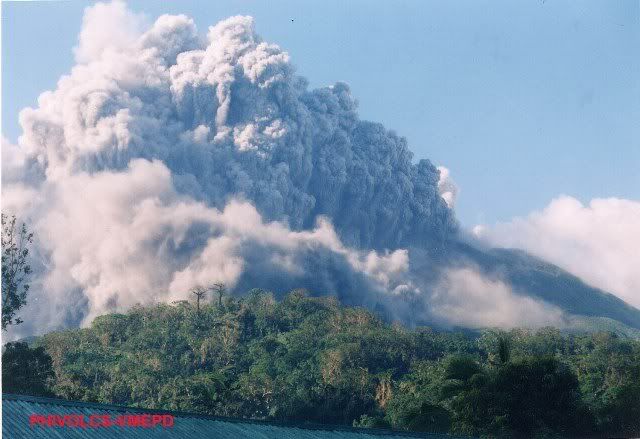
The Philippine Institute of Volcanology and Seismology (Phivolcs) declared Alert Level 1 on March 19, 2006 after it recorded increased seismic unrest. On June 8, 2006, volcanologists raised Alert Level 2 (moderate level of seismic unrest) after it spewed ash. On June 9, the resulting ash cloud damaged a number of houses in the nearby town of Casiguran, 5 kms north of the volcano, and reached Sorsogon City, about 20 kilometers north of Bulusan.

Bulusan is generally known for its sudden steam-driven or phreatic explosions and is one of the 22 active volcanoes in the Philippines, part of the so-called "Pacific ring of fire" made up of islands created by volcanic activity on the Western Pacific.


From Phivolcs

PHYSICAL FEATURES
Elevation: 1.559 km
Base Diameter: 15 km
Type of Volcano: Stratovolcano formed inside a caldera
Hotsprings: San Benon Springs, Mapaso Springs, San Vicente Springs, Masacrot Springs
Craters and Fissure:
1. Crater No. 1 or Blackbird Lake - 20 m in diameter and 15 m deep
2. Crater No. 2 - roughly oval in shape, 60 m by 30 m and 15 m deep
3. Crater No. 3 - approximately 90 m in diameter and 20 m deep
4. Crater No. 4 - near the NE rim, opened during the 1981 eruption

Fissure - located below Crater No. 4, measuring 5 to 8 m wide and about 100 m long
Adjacent Volcanic Edifice: Mt. Homahan, Mt. Binitacan, Mt. Batuan, Mt. Calungalan, Mt. Calaunan, Mt. Tabon-Tabon, Mt. Juban and Mt. Jormajan

GEOLOGICAL FEATURES
Rock Type: Two-pyroxene andesite in Bulusan, dacite associated with caldera
Tectonic Setting: Bicol Volcanic Chain
Age of Deposits:
a) 1500±300 years ( located at 12°45'N, 124°04'E)
b) 5,480±150 years ( located at Mapaso Stream Valley, 12°45'N, 124°04'E)
c) 5,800±100 years (located at a trail leading to Inlagadian, Casiguran, 12°49'N, 124°03'E)
d) 33,500±1,500 years (located at Magallanes Road, Juban, NW of Bulusan Volcano, 12°49'N, 123°58'E, sample taken from 30-40 m thick Irosin Caldera ashflow sheet)
SOURCE: Newhall, C. and Cruz, J. (Unpublished data)

VOLCANIC ACTIVITY
Number of Historical Eruptions: 15
Latest Eruption/Activity: 1994 November 27 - 1995 January

Eruption Type:
1. Phreatic (e.g. 1918-1922, 1980)
2. Strombolian (e.g. 1918-1919)
3. Caldera-forming (e.g. 40,000 YBP)

Precursors to Eruption:
1. Increase in the frequency of volcanic quakes with rumbling sounds
2. Increased steaming activity
3. Noticeable increase in the extent of drying up of vegetation around the volcano's upper slopes
4. Variation in the temperature of hot springs at San Benon
5. Rumbling sound
6. Increased amount of whitish to yellowish deposits of sulfur sublimates at NNW portion of the crater

VOLCANIC HAZARDS
Type of Hazards:
1. Pyroclastic flows (hot blasts, hot avalanche)
2. Lava flows
3. Lahars
4. Ashfall
Permanent Danger Zone: Four (4) km radius from the summit
Other Buffer Zones: 4 to 10 km from the summit (Probable Danger Zone)

MONITORING ACTIVITY
Volcano Observatory: Bulusan Volcano Observatory, Cabid-an, Sorsogon City
Monitored Methods:
1. Seismic
2. Ground deformation – precise leveling, electronic distance measurement (EDM), tilt
3. Hotspring temperature and flow rate measurements
4. Visual observations – steaming activity and other visually observed phenomena

Monitoring Stations:
A - Seismic Network
· Bulusan Volcano Observatory, Sorsogon City (VBN)
· Upper Inlagadian Hill Seismic Station (VBIH)
· Upper Mayong Payong Hill Seismic Station (VBMH)
· Mt. Jormajan Repeater Site (VBRJJ)
· Upper San Roque Seismic Station (VBSR)
· Salvacion Slope Repeater Site (VBSS)

B - Ground Deformation Network
· EDM : Survey lines at Salvacion-Hinde and Aniog-Lower Slope
· PRECISE LEVELING: Survey line at Mapaso
· TILT MEASUREMENT (wet) - San Benon